Registering the emergency equipment onboard with the appropriate authorities adds an extra layer of protection to the yacht and those onboard. This process is not only crucial for ensuring safety and security but also serves as a vital link to search and rescue operations in case of emergencies.
Whilst the following table of contents is brimming with abbreviations, each one will be thoroughly explained in the upcoming article. We focus on the safety and security aspects of each unique piece of kit found aboard the yacht and why registration is so important.
MMSI
MMSI, or Maritime Mobile Service Identity, is a unique nine-digit identification number assigned to a yacht's maritime radio set.
Likening the MMSI to a personal mobile number is a helpful analogy. Similar to how your mobile number uniquely identifies you, an MMSI serves as a distinct identifier for maritime communication. When a vessel communicates using its MMSI, it allows for clear and immediate recognition, much like how a recipient sees your number and identity when you make a call.
MMSI numbers are typically allocated by national authorities overseeing telecommunication regulations. In the United States, the Federal Communications Commission (FCC) is responsible for assigning MMSI numbers, while in the UK, the task falls under Ofcom (Office of Communications).
The initial three digits of an MMSI number serve as the country code. For instance, in a standard nine-digit MMSI, the prefix '235' designates registration or assignment by a regulatory authority in the United Kingdom. For US-registered vessels, the first three digits will be '366.'
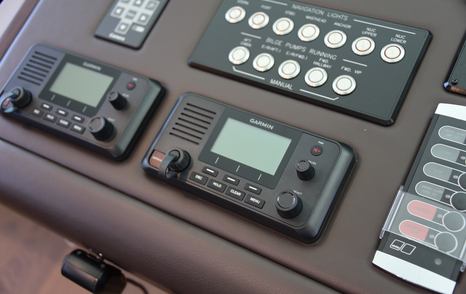
When registering the MMSI, the central registration system of the issuing authority typically requires personal information. This includes a permanent address, contact numbers for the yacht owner, and additional shore contact numbers such as those for the next of kin and, if applicable, the yacht management company. Providing accurate and up-to-date information during the registration process ensures effective communication and coordination in case of emergencies or when authorities need to reach out regarding the vessel.
Communication via the ship's radio using the MMSI number provides an added layer of security, especially if the yacht is stolen. The MMSI uniquely identifies the vessel, allowing for authenticated communication. In case of unauthorized or suspicious activities, the MMSI becomes a tool for authorities to verify the identity of the vessel and take appropriate action.
The MMSI number is included in the information registered to the vessel's EPIRB, see below.
EPIRB
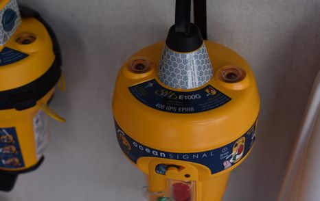
An EPIRB (Emergency Position Indicating Radio Beacon) is a distress signaling device used in emergencies at sea. It broadcasts a signal to satellites, which then relay the distress signal and the vessel's location to search and rescue authorities.

- Authentication:
Registration ensures that the EPIRB is linked to a specific vessel, with its corresponding MMSI number, providing an added layer of security.
- Ownership Verification:
By registering the EPIRB, ownership details and vessel information are on record. This helps authorities confirm the legitimacy of the distress call and contact the vessel owner or operator promptly.
- Swift Response:
In the event of an emergency, a registered EPIRB allows for a faster and more accurate response from search and rescue authorities.
In a distress situation, when the EPIRB is activated, it broadcasts a distress signal with the associated MMSI, alerting search and rescue authorities to the emergency and providing the vessel's location. In addition to transmitting precise distress location, the EPIRB records will provide additional details like the type of yacht, owner's details, likely activity, and the maximum number of persons onboard.
It's important to clarify that while an EPIRB and a VHF radio distress message serve distinct purposes, they are associated with the same MMSI number.
- Updated Information:
Keeping the registration details current is essential. Any changes in vessel ownership or configuration should be promptly updated, ensuring that authorities have the most accurate information during emergency responses.
SART
A SART (Search and Rescue Radar Transponder) is a maritime safety device designed to aid in search and rescue operations. When activated, typically in emergency situations, a SART produces radar signals that can be detected by search and rescue vessels and aircraft. This helps rescuers pinpoint the location of the distressed vessel or survival craft at sea.
The SART is a piece of equipment authorized by the Ship Portable Radio Licences authority and should be registered through the national telecommunications organization.
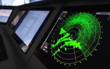
The radar-SART is used to locate a survival craft or distressed vessel by creating a series of dots on a rescuing ship's radar display.
When a radar-SART is in range, it responds during each of the 12 slow sweeps of the radar. This shows up as a line of 12 dots, evenly spaced about 0.64 nautical miles apart. As the range to the radar-SART decreases to around 1 nautical mile, the radar may display 12 more responses and mix with the original line of dots. As the radar gets closer, these dots become stronger and larger, initially forming arcs until the SART is within 1 nautical mile, where they become full circles, indicating the active SART is in the general area.
An AIS SART (Automatic Identification System Search and Rescue Transmitter) is a maritime safety device designed for search and rescue operations. It operates within the Automatic Identification System (AIS), a technology widely used for vessel tracking and collision avoidance. The AIS SART is specifically intended for distress situations.
When activated, the AIS SART broadcasts a series of signals that include the distressed vessel's identification information, position, and other relevant details. This information is then received by nearby vessels and shore stations equipped with AIS receivers. Search and rescue authorities use this transmitted data to quickly and accurately locate the distressed vessel, facilitating a prompt response to the emergency.
AIS
The Automatic Identification System (AIS) is an automated tracking system utilized by vessels at sea. Its primary purpose is to enable observation of marine traffic in their vicinity and be visible to that traffic. To achieve this, a dedicated VHF AIS transceiver will be fitted onboard. This device allows the monitoring of local maritime activity on an AIS-enabled chartplotter or computer screen while simultaneously transmitting its own information to other AIS receivers.

AIS provides crucial information, including unique identification, position, course, and speed, which can be displayed on electronic screens or Electronic Chart Display and Information Systems (ECDIS). The system is designed to support watchstanding officers and enable maritime authorities to monitor and track vessel movements. AIS seamlessly integrates a standardized VHF transceiver with a positioning system like a Global Positioning System (GPS) receiver.
Maritime Security
AIS plays a crucial role in enhancing maritime security by enabling authorities to identify specific vessels and monitor their activities within or near a nation's Exclusive Economic Zone. When AIS data is integrated with existing radar systems, authorities gain a clearer distinction between vessels. The information provided by AIS is automatically analyzed to establish typical activity patterns for each vessel. Any deviation from these patterns triggers an alert, helping authorities identify potential threats and allocate security resources more efficiently.
Overall, AIS significantly improves maritime awareness, contributing to heightened security and control measures.
PLB
A Personal Locator Beacon (PLB) is a compact, handheld safety device functioning as a personal EPIRB. When activated, it utilizes satellite systems to broadcast the user's position at sea.
For optimal use, attach the PLB to your personal lifejacket, ensuring quick access for alerting search and rescue services during emergencies. In the event of falling overboard, manually activate the PLB, sending a distress alert directly to the coastguard via orbiting satellites on the 406MHz frequency.
If a beacon lacks integrated GPS, its signal may need detection by two or three satellites for an accurate position estimate, potentially delaying the initiation of search and rescue (SAR) efforts.
Regarding personal security, the transmitted signal includes a digital message, allowing the transmission of encoded data like the beacon's unique identifier. This links the beacon to the Beacon Registry, providing critical 24/7 information to the rescue coordination center.
BUOYS
Although it's not an acronym, writing it in lowercase may have affected the aesthetics of our table of contents for this specific article. Here, we include a brief note about buoys, such as lifebuoys or life rings.

The Safety of Life at Sea (SOLAS) regulations, specifically SOLAS CHAPTER III, Regulation 7 - 1.4, stipulates that ...
Each lifebuoy shall be marked in block capitals of the Roman alphabet with the name and port of registry of the ship on which it is carried.
While pleasure vessels may not be obligated to adhere to SOLAS regulations until reaching a certain size, it is advisable to mark lifebuoys on the yacht as per the SOLAS requirements. This precaution ensures that in the unfortunate event of a capsize and sinking, if a lifebuoy is the only thing afloat, having it marked with the yacht's name and port of registry facilitates search and rescue efforts to bring individuals to safety.
